Smith Rock State Park
Rising from the high desert floor of central Oregon, Smith Rock State Park is one of the most visually striking landscapes in the Pacific Northwest. The park centers on a dramatic canyon carved by the Crooked River, with volcanic rock formations towering hundreds of feet above the water. It draws visitors from around the world, primarily for its rock climbing, but also for canyon hiking, wildlife watching, and stark desert scenery unlike anything else in the state park system.
Rock Climbing at Smith Rock
Smith Rock is widely credited as the birthplace of American sport climbing. In the 1980s, climbers pioneered difficult bolted routes on the welded tuff and basalt walls here, pushing the standards of the sport in the United States. Today the park offers more than 1,000 established routes ranging from beginner-friendly single-pitch climbs to some of the most technically demanding routes in the country. Monkey Face, a freestanding spire that resembles a primate’s profile, is the park’s most iconic formation and a bucket-list objective for experienced climbers. Morning Glory Wall, Red Wall, and the Dihedrals are among the most heavily visited crags. Climbers should check current closure notices and posted signs before climbing, as some routes are closed seasonally to protect nesting raptors.
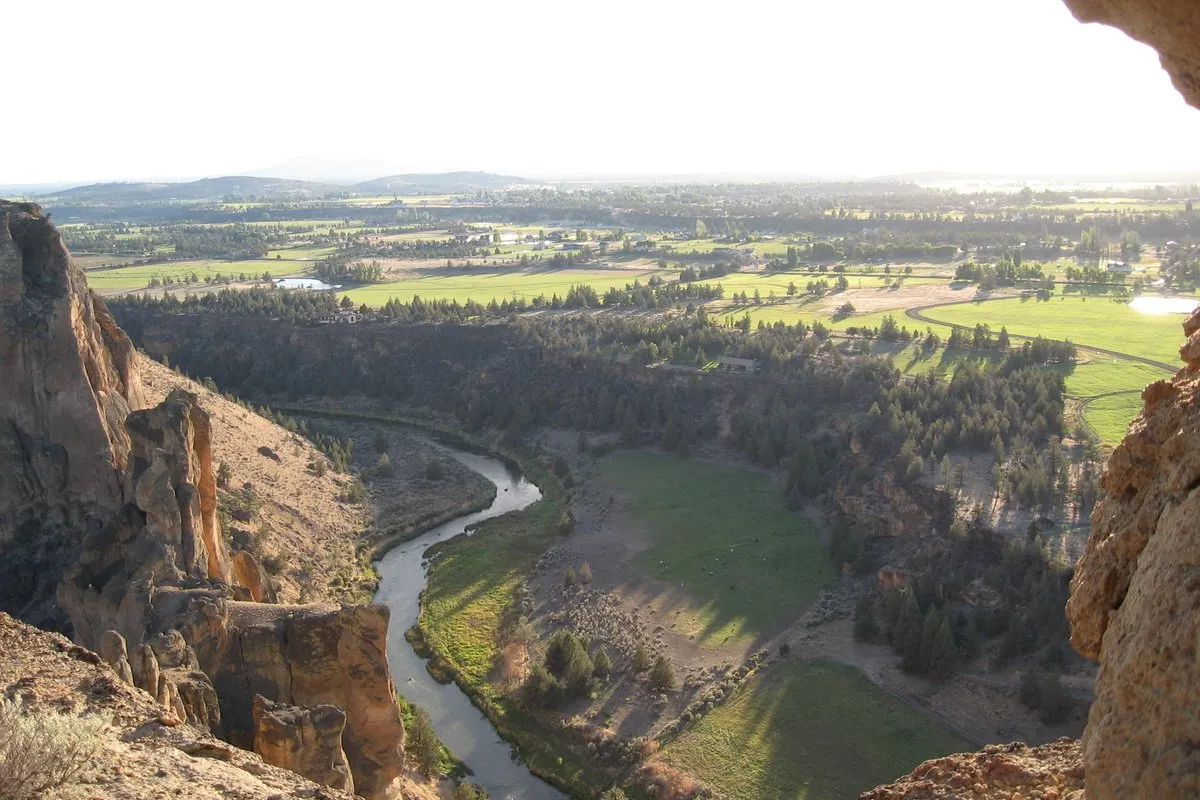
Canyon Hiking and the Misery Ridge Loop
Even visitors with no interest in climbing find the hiking here exceptional. The most popular route in the park is the Misery Ridge Loop, a roughly four-mile circuit that climbs steeply to the top of Misery Ridge before descending along the river on the Canyon Trail. The elevation gain is significant and the trail is exposed, but the views from the ridge across the canyon to the Cascade peaks, including the Three Sisters and Mount Jefferson, are expansive. The River Trail runs along the Crooked River at the base of the cliffs and offers a lower-effort alternative with dramatic upward views of the rock formations. The full trail network in the park is around eight miles, with options that can be combined into longer loops or shortened for families with children.
The Crooked River and Canyon Floor
The Crooked River winds through the bottom of the canyon and gives the park much of its character. The riparian zone along the river supports cottonwoods and willows in contrast to the surrounding sagebrush desert, and the water draws birds and other wildlife throughout the year. Fishing is allowed in the river, though conditions vary and anglers should check current Oregon Department of Fish and Wildlife regulations before visiting. A footbridge near the main trailhead provides access across the river to the primary trail network.
Pet Policy
Leashed pets are welcome on all trails and in day-use areas of the park. Leashes must be six feet or shorter at all times. Pets must remain leashed and under control; climbers and slackliners must not leave leashed dogs unattended at the base of routes or lines. Owners are required to clean up after their animals. Given the presence of rattlesnakes along trails, keeping dogs close and on leash is especially important for their safety.
Wildlife to Be Aware Of
Western rattlesnakes are present throughout the park and are most active from spring through early fall when temperatures are warm. They are commonly encountered on trails, near rocky outcroppings, and in brushy areas. Watch where you step and where you place your hands, particularly when scrambling or moving off-trail. If you encounter a rattlesnake, give it space and wait for it to move on. Bites are rare but serious, and immediate medical attention is required if one occurs.
Ground squirrels and other small mammals are visible and active throughout the park, particularly in the open areas near the trailheads and picnic zones. They may approach visitors hoping for food, but feeding them is harmful to their health and can lead to aggressive behavior. Store food securely and do not leave snacks unattended on the ground.
Golden eagles and prairie falcons nest on the cliff faces, and their presence is one reason Smith Rock holds such ecological significance beyond its geology. During nesting season — with closures typically running from around January 15 to August 1, though specific routes vary by nesting activity — some climbing routes are closed to prevent disturbance to active nest sites. Closures are posted at the park entrance and updated regularly. Climbers should review the current closure map before heading out. Observers with binoculars can often spot these birds from trail viewpoints without disturbing them.
Practical Information
Smith Rock State Park is located near the town of Terrebonne, Oregon, approximately nine miles north of Redmond and 25 miles north of Bend. From Highway 97, take the Terrebonne exit and follow signs northeast to the park. The access road is paved and the main parking area is well marked.
Day-use parking permits cost $10/day for Oregon residents and $12/day for non-residents, per vehicle; walk-in, bicycle, and transit visitors do not need a permit. Standard Oregon State Parks annual permits are accepted. Smith Rock offers a primitive walk-in bivouac area for tent campers; it is first-come, first-served with no reservations, open seasonally as weather allows. RV camping, sleeping in vehicles, and open fires are not allowed in the bivouac area.
The park is open year-round. Spring and fall offer the most comfortable temperatures for hiking and climbing. Summer days can be intensely hot, and early morning starts are strongly advised. Winter visits are possible and often uncrowded, though some trails may be muddy or icy. Drinking water and restrooms are available at the main trailhead.
Frequently Asked Questions
What is the entry fee for Smith Rock State Park?
Day-use parking permits cost $10/day for Oregon residents and $12/day for non-residents, per vehicle. Walk-in, bicycle, and transit visitors do not need a permit. Standard Oregon State Parks annual permits are accepted.
Are dogs allowed on the trails at Smith Rock?
Leashed pets are welcome on all trails and day-use areas, with leashes no longer than six feet, though owners should keep dogs close given the presence of rattlesnakes along the trails.
Are any climbing routes at Smith Rock closed?
Some climbing routes are seasonally closed from around January 15 to August 1 to protect nesting golden eagles and prairie falcons, with specific closures varying by nesting activity. Climbers should check current closure notices and posted signs before climbing.
How difficult is the Misery Ridge Loop hike?
The Misery Ridge Loop is a roughly four-mile circuit with significant elevation gain and exposed terrain, though it rewards hikers with expansive views of the canyon and Cascade peaks including the Three Sisters and Mount Jefferson.