Deception Pass State Park
Deception Pass State Park occupies the dramatic northern tip of Whidbey Island and the southern shore of Fidalgo Island in Washington, connected by one of the most recognizable bridges in the Pacific Northwest. The park takes its name from the narrow tidal strait beneath that bridge, where powerful currents churn through rocky channels and the water changes direction with each tide. With 3,854 acres of coastline, freshwater lakes, and old-growth forest, it is the most visited state park in Washington and one of the most geologically striking landscapes on Puget Sound.
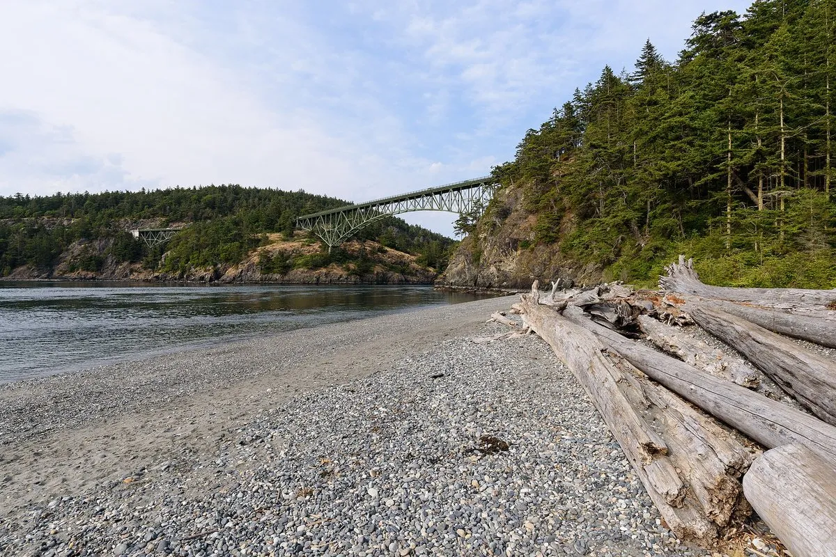
Deception Pass Bridge and the Strait
The bridge itself draws visitors who have no intention of hiking anywhere. Completed in 1935, the bridge project involved the Washington State Highway Department, Puget Construction Company, Wallace Bridge and Structural Company, and CCC crews who helped build the approach roadbeds. The bridge complex includes the 976-foot Deception Pass span and the 511-foot Canoe Pass span, for a total length of 1,487 feet, at a height of about 180 feet above the water. Pedestrian walkways on both sides allow you to stand directly over the strait and watch the current move through below, sometimes reaching 8 knots on a strong tidal exchange. The view from the bridge takes in rocky headlands, kelp beds, and forested slopes in every direction. Parking areas at both the north and south ends of the bridge provide access to the walkways and to the trail systems that branch out from the strait.
Sunset is the bridge’s signature hour. The western-facing exposure across the strait gives long golden light on the spans, the islands, and the cliffs, and the bridge is one of the most photographed sunset locations in the Pacific Northwest. The Bowman Bay area and the rocky shoreline at Rosario Head also offer strong west-facing sunset vantage points without the foot traffic on the bridge walkways. Plan to arrive 30 to 45 minutes before sunset for parking and to scout a spot, and dress for cool, breezy conditions even in summer.
Trails Through Forest and Coastline
The park contains 38 miles of trails ranging from short interpretive walks to full-day routes that connect forest interiors with exposed coastal bluffs. The Deception Pass Loop combines sections of the North Beach Trail, the Goose Rock Perimeter Trail, and the connecting paths near the bridge, covering roughly 4 miles with significant elevation gain on Goose Rock. The summit of Goose Rock sits at 484 feet and offers open views of the San Juan Islands to the north and Skagit Bay to the east. Rosario Head, accessed via a short trail from Bowman Bay, is a rocky promontory with 270-degree water views and is one of the better places in the park to watch for marine life from shore. The forest trails on the interior of Whidbey Island pass through second-growth mixed forest with pockets of old-growth Douglas fir and madrone, particularly along the ridge above Cranberry Lake.
Swimming, Kayaking, and Beach Access
The park has two distinct types of waterfront. North Beach and West Beach face the Strait of Juan de Fuca and offer wide sandy and cobble shores with strong afternoon winds, making them popular for kite flying and surf watching but less suitable for swimming. Cranberry Lake and Pass Lake are the calmer freshwater options. Cranberry Lake has a designated swimming beach with a gradual entry and is the most family-friendly water access in the park. Pass Lake on the north side of the bridge is open to catch-and-release fly fishing only and draws anglers targeting rainbow and brown trout. Kayakers and paddlers use the protected hand-launch access at Bowman Bay, which avoids the dangerous currents in the main channel. The Bowman Bay pier and trailered-vessel launch are closed indefinitely, but kayaks, paddleboards, and canoes still have access. Paddling directly through Deception Pass is possible only for experienced paddlers who understand tidal timing.
Camping
The park has more than 300 campsites spread across several loops, including 172 standard sites and 134 partial-hookup sites, plus dedicated hiker/biker sites. The main campground near Cranberry Lake accommodates both tents and large RVs. A separate group camp is available for organized parties. Cabins at Quarry Pond provide a more sheltered option. Reservations are strongly recommended from late spring through Labor Day, as the campground fills most summer weekends well in advance. Sites can be reserved through the Washington State Parks reservation system.
Pet Policy
Leashed pets are welcome in most areas of the park, including on trails and in campgrounds. The standard leash length is 8 feet. Pets are not permitted on designated swimming beaches or in certain sensitive wildlife areas, including the Rosario tide pool areas and Kukutali Preserve. Owners are responsible for cleaning up after their animals. Leaving a pet unattended at a campsite is not allowed.
Wildlife to Be Aware Of
Harbor seals are a regular presence at Deception Pass and are often seen hauled out on the rocks near Rosario Head and along the shoreline at low tide. They may appear motionless or ill, but this is normal resting behavior. Do not approach, touch, or attempt to return a seal to the water. Getting too close can cause the animal to abandon a haul-out site and can trigger bites if the animal feels cornered. River otters move through the tidal areas and along the edges of Cranberry Lake and Pass Lake. They are active and curious, but feeding them disrupts their foraging behavior and is prohibited. Bald eagles nest in the old-growth trees throughout the park. Stay well back from any tree with an active nest, and avoid lingering beneath a nest site during the spring breeding season. Excessive disturbance can cause adults to abandon eggs or young.
On the trail, watch for stinging nettles and poison oak along many of the lower corridors, particularly in damp areas and near stream crossings. Stinging nettles cause immediate skin irritation on contact. Poison oak produces an oily resin that causes a delayed allergic rash and can transfer from clothing, gear, and pet fur. Wearing long pants and closed shoes on wooded trails reduces exposure to both plants.
Practical Information
Deception Pass State Park is located at 41229 State Route 20 on Whidbey Island, approximately 9 miles north of Oak Harbor and 9 miles south of Anacortes. From the south, take SR-20 north from Oak Harbor. From the north, the park is accessible via the Anacortes area off I-5 to SR-20 west. The park is open year-round. A Discover Pass is required for vehicle parking: $45 for an annual pass or $10 for a daily pass. Pedestrians and cyclists enter without a fee. Summer weekends bring heavy traffic and limited parking, particularly near the bridge. Arriving before 9 a.m. on peak days significantly improves the experience.
Frequently Asked Questions
Is a Discover Pass required to visit Deception Pass State Park?
Vehicle parking at Deception Pass State Park requires a Discover Pass: $45 annual or $10 for one day. Transaction/vendor fees may apply. Pedestrians, cyclists, and other non-motorized visitors do not need a Discover Pass.
Are dogs allowed at Deception Pass State Park?
Dogs are allowed in most areas on a leash no longer than 8 feet, but not on designated swim beaches, in Rosario tide pool areas, or anywhere in Kukutali Preserve. Keep pets under control around wildlife such as harbor seals and bald eagles.
Can you swim at Deception Pass State Park?
Cranberry Lake has a designated swimming beach with a gradual entry and is the most family-friendly water access in the park. The ocean-facing beaches at North Beach and West Beach are not well suited for swimming due to strong afternoon winds and rough conditions.
Is it safe to kayak through Deception Pass?
Paddling directly through Deception Pass is only recommended for experienced paddlers who understand tidal timing, as currents in the main channel can reach 8 knots on a strong tidal exchange. Beginners and casual paddlers are better served by the protected hand-launch access at Bowman Bay, which avoids the most dangerous water.
How did Deception Pass get its name?
British explorer George Vancouver named it in 1792 after being deceived into thinking it was a bay, only to discover it was actually a navigable channel separating Whidbey Island from Fidalgo Island. The name stuck, and the strait beneath the bridge still reflects that moment of geographic surprise.
Are there tide pools at Deception Pass State Park?
Rosario Head, reached by a short trail from Bowman Bay, has accessible intertidal areas with sea stars, anemones, and other marine life best viewed at low tide. Dogs are not permitted in the Rosario tide pool area to protect the marine habitat.